![]()
| HOME | Current Position Report | Logs & Stories | Photos | People | The Boat | Contact Us |
|
| |||||||
| |||||||
In this section... Logs Index 2005
|
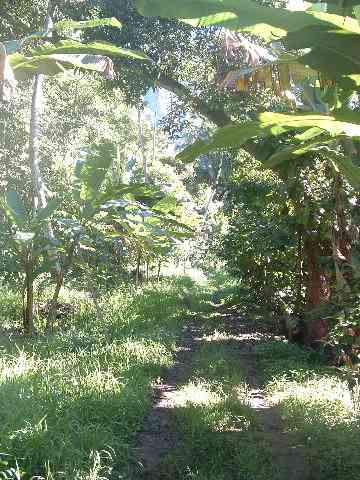
Logs & Stories - June 2005Marquesas Friday, June 3 Bill: We'd been trying to reconnect with Ishmael, our fruit benefactor, and Karryn and I had walked up to his house twice. The first time, he wasn't home, but on the second he and his family were taking their mid-day nap. We made introductions between Karryn and Ishmael's wife Tanya, then talked briefly. He invited us to come back to have lunch in a few days. Today was that lunch. All four of us hiked up the hill to Ishmael's, arriving around noon. Unfortunately, only Ishmael was home to greet us because his son had stepped on a nail at school and his foot had gotten an infection that made a trip to the hospital appropriate. He was in good condition, and Ishmael and Tanya were taking turns staying with him. Even so, Ishmael had gone to great effort to make and have lunch with us, and we were treated to a salad with shrimp, cabbage, carrots and potatoes, chicken cooked with green papayas, onions and coconut milk, rice, grilled chicken, and somewhere along the way there was breadfruit. The food was all very good, but I had a sense that Ishmael was disappointed at our appetites; judging by the amount of food there, I think the average portion size is bigger than what we eat in a meal. We finished up with homemade carasol ice cream along with a fruit salad served in coconut halves that Ishmael whacked in half right before serving it up. As our lunch conversation unfolded, we got a better sense of his family history. Ishmael, who in spite of his name is very Polynesian looking, is the grandson of a German immigrant that arrived in paradise around the end of WWII. He was born in Tahiti, but grew up on Nuka Hiva. He'd returned to Tahiti for high school, then spent six years working in the island's hotels and resorts. He'd learned to speak English, made a trip to France, married, and returned home with a small family. It turns out that Ishmael has nine brothers and sisters. One brother, a communist, lives next door. Another brother, his face half covered in tattoos, lives on the remote north side of the island in Anaho Bay, reputed to be the quietest anchorage in the Marquesas. One sister lives on an adjoining lot and two others live in Paris. I'm hoping we'll be able to meet the ones who live here as we explore the island. One of the things I've been curious about is Nuku Hiva's food and water supplies. We've been told repeatedly that Taiohae's water supply is undrinkable, but I hadn't seen any evidence of the five-gallon water jugs that are so common in Mexico, which frequently has similar issues. Ishmael informed us that he used his uncle's truck (the same one he'd given us the ride in earlier) to drive over to Taipaivai, the next valley to the east, to collect good water. One of the curiosities about the food supply is that the food in the stores is so expensive. This makes intuitive sense to me, since packaged goods manufactured elsewhere take a lot of time, effort, equipment and energy to transport themselves to Taiohae's shelves. But the lack of an economic structure here made me question how locals would come up with money to buy food. From talking to Ishmael, though, it appears that the food mechanism here works very differently than I'm accustomed to. In the US, most of the good flows through retail stores -- my impression is that the impact of non-business gardening, fishing, ranching, winemaking, etc., is pretty minimal. This place appears to be a bit different. One of the things that is truly amazing is the number of food-bearing trees you see, most of which seem pretty laden with fruit. At some point in the past, this island fed 30,000 folks, over ten times the current population, and I suspect these long-gone people planted a lot of the trees I'm seeing. Also, my impression is that the Marquesas Islands also have many wild pigs and goats that the locals hunt - in fact, several guides have mentioned that the overpopulation of goats on some of the islands has been substantial enough to lead to environmental damage. Probably just like everybody else's, Ishmael's yard provides a great deal - bananas, limes, papayas, pomplemouse, breadfruit and the ever-present Hogtestical fruit (carasol). He also has chickens and a pig in the back yard. They sent us home with eggs that were even better than the local ones sold in the stores. In addition, his family has 300 cattle that are kept up on the plateau in the middle of the island. Generally, it appears that these people live a more subsistence existence, where the food they consume comes from immediately around them, and that the presence of family members, friends and neighbors creates a social environment where folks get together and do things communally. With only four small stores in Taiohae, it's hard for me to imagine that the amount of food flowing through retail is significant. One of the things I'm continually mindful of is that I've been able to share a bit in this experience by virtue of Ishmael's generosity and command of the English language. In the course of our conversation, Ishmael mentioned that there was a commercial farm on the north end of the island that was providing most of the vegetables that are sold at the stores in Taiohae. From what I've seen of Nuku Hiva so far, the soil here is pretty full of rocks - the stone walls you see everywhere are a testament to that. I'm wondering if the north side of the island looks different than what I'm seeing on the south side.
Thursday, June 10Karryn:
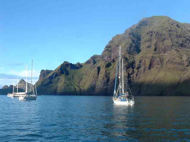
The bay does have no-nos, irritating bugs (sand flies) that bite without causing pain, or any sensation at all; however, some time later (12-36 hours), one discovers small red bumps that itch in an amazingly spectacular way as well. Except for Bill, who seems to have no reaction to them other than the red marks on his skin. We've been hitting him occasionally, to make up for what we're going through. Well, not really - we just want to. We're still doing well, although I've learned that when it rains, it pours and then it's very, very humid afterwards. I'm not a big fan of the humidity here; even after two summers and three years in Mexico, I find it very uncomfortable if there is sunshine and no breeze. Daniel's Bay has some other Marquesan name, but it's been informally renamed because of a man of legendary repute. Daniel, now in his 80's, has lived here much of his life and has become something of an icon to cruisers who are endlessly treated to his friendliness. The bay was a 'Survivor' location several years ago, and the show moved Daniel and his wife Antoinette to the other lobe of the bay, building them a new house. The view is incredible, but the real reason we moved here is to do a couple of repairs - one to the underwing, the other to one of the dinghies. The water in Daniel's bay is flatter, making Bill's repair work on the underwing a lot easier. The underwing, for those unfamiliar with the anatomy of a cruising trimaran, is the bottom side of the structure that connects the central hull to the outer hull, one on each side. During the passage from Mexico we cracked a stringer in the compartment just in front of the forward main strength bulkhead on the port side (my clothing cubby). We didn't note anything that could have caused the damage, but assume a wave thumped us hard enough to deflect the plywood skin and crack the stringer -- it's near the leading edge of the wing, so particularly vulnerable to that sort of thing. The wood I bought to sister the stringer was over $1 a foot for 4cm x 4cm -- I had to buy a whole 18 feet board even though we only needed eight feet! Also, during an evening outing we left the dinghy tied to a concrete wall and it ended up in a losing battle with an inflatable with an outboard engine - we left thinking the tide was low, but when we came back we found that the tide had fallen quite a bit further and in the process our plywood pram had gotten caught under the inflatable. So it needs repairs as well. We post the tides on our white board every day now! The access to shore at Taiohae Bay is not good, although better than many places in these islands, I understand -- a cement sea wall with either cut-in stairs or lousy ladders is the only option besides the beach. I don't like the beach when the tide is low or the swell is up, and the sea wall is obviously a bad place when all the other dinghies are inflatables with engines. Those things used to look so soft!
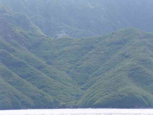
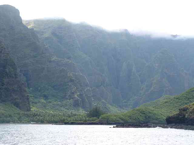
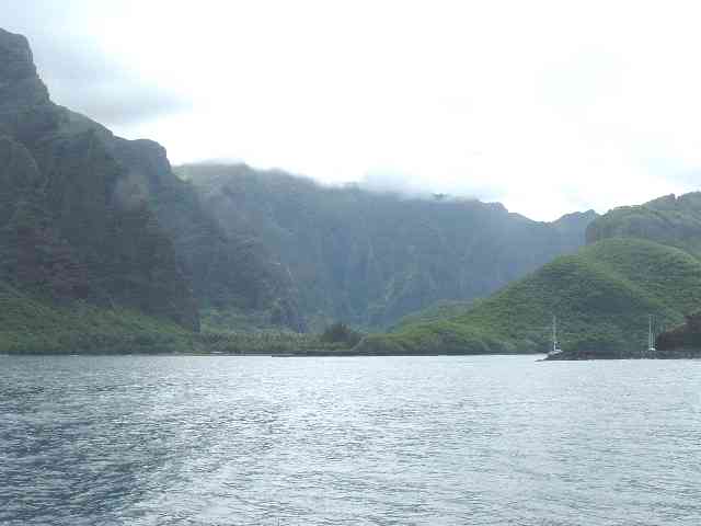
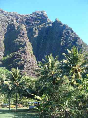
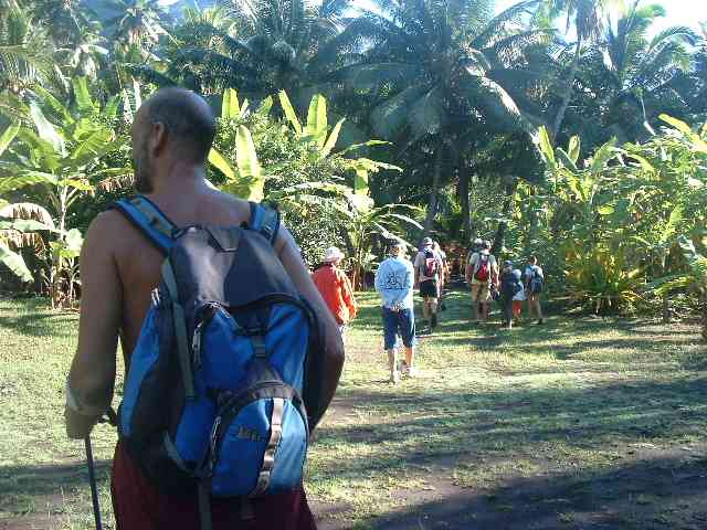
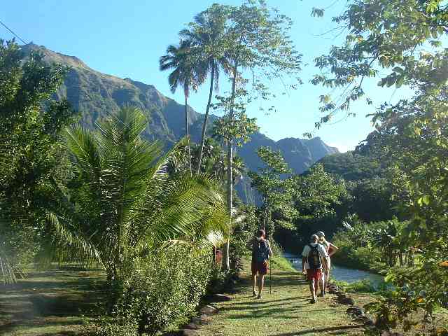
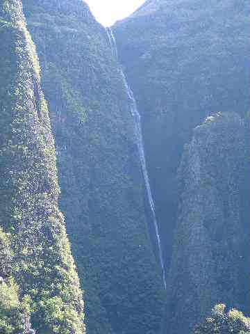
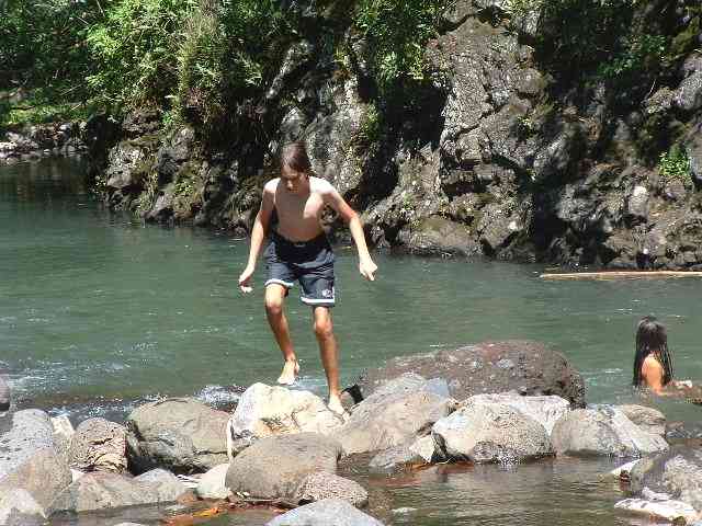
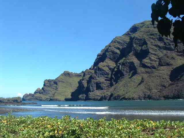
Monday, June 13Jackson: We're back in Taiohae Bay now, after we spent two days in Anse Hakatea in Baie Taioa (referred to by cruisers as Daniel's Bay for the Marquesan who has lived there for decades). The entrance to the bay is very dramatic. At first the entrance is invisible and gradually appears as you get more west. On the west side of the bay are some huge volcanic cliffs, all of them more than a thousand feet high. The highest is about fifteen hundred feet. The valley behind the west part of the bay looks really flat (although it isn't), contrasting with the pinnacles that shoot up on the edge of it. And, instead of hearing cars and surf (like in Taiohae), you hear birds. There are two blowholes we know of on the west side (the cliff side). The interesting thing is that one is sideways. It is more a cave then a blowhole, but it blows out spray when a wave goes inside it. It is sideways because the spray comes out like the kind of garden hose end that has different modes (mist, jet, etc.). There is a nice-looking white beach in the east bay where you anchor (I don't know if it really is nice; Naomi is the only person on the boat who went there, and she is on another boat with other girls right now). The west bay where you don't anchor has a stream that you land in (where you land is more like a small inlet with dark sand). The stream is nice to swim in because it has mud on the bottom instead of sand, and since freshwater is lighter than salt, it tastes fresh on top and you can pretend that you are bathing in an unlimited supply of fresh water. On the last day we hiked with a bunch of other cruisers to the waterfall, which is something like the third highest in the world. The hike was a long walk which included wading through waist-high ferns and shrubs, jumping over pig-churned mud, crossing fast streams, and the fact that you can't actually see the waterfall (except from the path about a mile before the falls).
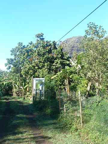
Yes, that is a phone booth in the photo on the right!
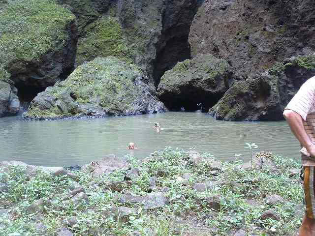
The main stream gets deep near the two places where you cross it (deep enough to swim comfortably in). The first time you have to go a bit upstream to reach the deep place, the second time, a bit downstream. The second crossing is a great place to swim, but a bit hard to reach. You have to walk over rocks and climb over branches (on a log I saw beetles mating) and there are rocks in the shallower water (but not sharp ones). But it is worth it. Once you get to where the stream goes against the cliff, I think it gets to at least eight feet deep. There are old pre-European walls and platforms everywhere. There are stacks of rocks marking the trail.
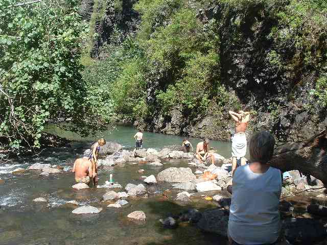
There are three important things about the last swim: First, spray and the wind blow straight in your face so it is easier to swim backwards. Second, there are some rocks on the right side where there is a huge alcove into the canyon wall. You can stand on these rocks. You can also hang onto or sit on the point at the upper edge of the alcove where the rock flattens out and you can sit down. Third, there are boulders underwater with large gaps between them, so the depth varies from thigh-high to over your head. There are shrimp in the pool, but how they got there I have no idea. I guess they are the product of the same mysterious principle that allows tadpoles to appear in pools in Baja canyons after it rains. It was cold in the canyon with the waterfall, so we didn't spend long swimming there. We got dressed, and then walked down the trail looking for a swimming hole with sunlight. We didn't take long to find it.
Then we dried off and finished the long walk to the boat. We left Seafire at 7:30am, and got back around 2pm.
|
|
Last
Updated: 11/28/16 |
| Web Curator |